Croatia has eight national parks: Brijuni, Kornati, Krka, Mljet, Paklenica, Plitvice Lakes, Risnjak and North Velebit. Their total area is 994 km²; 759 km² is land and 235 km² is water. The most popular Croatian National Parks are Plitvice Lakes, followed by Krka, Brijuni and Paklenica. The Croatian law on the preservation of nature defines national parks as one of the eight types of protected areas of nature. Another notable category is a nature park, of which there are eleven. Each of the national parks is maintained by a separate institution, overseen and funded by the government ministry of nature conservation and spatial development.
Marking the 10th anniversary of the Zagreb Amateur Radio Society and the 50th anniversary of the Croatian national parks, Zagreb Amateur Radio Society has launched a diploma National Parks. In addition to marking these anniversaries, the goal is to open up these Croatian natural beauties to domestic and foreign radio
operators, and encourage them to visit the national parks of Croatia. The diploma includes all Croatian national parks.
|
  Brijuni National Park (since October 27, 1983) - Brijuni consists of 14 islands and islets having a total surface area of 36.3 km². Thanks to its indented coastline, diverse flora and fauna, Brijuni is sometimes referred to as Heaven on Earthall. Brijuni archipelago are attractive group of islands near Istria Peninsula, with the main islands Veli Brijun that is Croatia National Park and open to visitors. The fact that it was visited by the elite of Austrian, Hungarian and German aristocracy when Istria was part of the Austro-Hungarian monarchy speaks of its beauty and charm. The islands are rich in natural beauties, flora and fauna brought here from various parts of the world. On Brijuni there is an attractive archaeological site the Byzantine castrum and luxurious Roman villa, Ethnographic collection, Collection of frescoes, Archaeological Museum and Natural history exhibit. The Brijuni archipelago is separated from the mainland by the two-miles-wide Fazana Channel
to the northwest of Pula. The archipelago stretches over 736 hectares and forms a 30 miles long coast. It is a place where sumptuous wildlife (680 different local and exotic plants, 150 bird species, etc.) couples with a wealth of historical traces ranging from a Neolithic settlement and Illyrian ruins, to monuments dating from the Byzantine period and the Middle Ages, as well as from Austro-Hungarian architecture to a more recent time. Brijuni Minor fortress, built in the late 19th century is the largest edifice in the defence system of the Austro-Hungarian central naval base of Pula. Stretching over 15.750 square meters, the edifice is 175 meters long and 90 meters large. (9ANP-001, 9AFF-001)
Brijuni National Park (since October 27, 1983) - Brijuni consists of 14 islands and islets having a total surface area of 36.3 km². Thanks to its indented coastline, diverse flora and fauna, Brijuni is sometimes referred to as Heaven on Earthall. Brijuni archipelago are attractive group of islands near Istria Peninsula, with the main islands Veli Brijun that is Croatia National Park and open to visitors. The fact that it was visited by the elite of Austrian, Hungarian and German aristocracy when Istria was part of the Austro-Hungarian monarchy speaks of its beauty and charm. The islands are rich in natural beauties, flora and fauna brought here from various parts of the world. On Brijuni there is an attractive archaeological site the Byzantine castrum and luxurious Roman villa, Ethnographic collection, Collection of frescoes, Archaeological Museum and Natural history exhibit. The Brijuni archipelago is separated from the mainland by the two-miles-wide Fazana Channel
to the northwest of Pula. The archipelago stretches over 736 hectares and forms a 30 miles long coast. It is a place where sumptuous wildlife (680 different local and exotic plants, 150 bird species, etc.) couples with a wealth of historical traces ranging from a Neolithic settlement and Illyrian ruins, to monuments dating from the Byzantine period and the Middle Ages, as well as from Austro-Hungarian architecture to a more recent time. Brijuni Minor fortress, built in the late 19th century is the largest edifice in the defence system of the Austro-Hungarian central naval base of Pula. Stretching over 15.750 square meters, the edifice is 175 meters long and 90 meters large. (9ANP-001, 9AFF-001)
|
 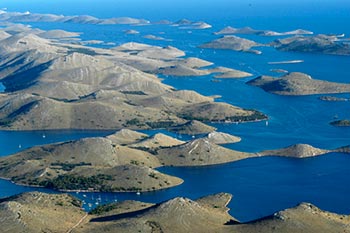 National Park Kornati (since July 24, 1980) - group of about 130 islands, islets and reefs sprinkled in the deep blue sea of the Adriatic covering an area of about 64 sq km, has a total surface area of 220 km², comprising 89 islands, islets and reefs. Land accounts for only around 1/4 of the park’s area – the rest is a marine ecosystem. National Park is a The Kornati archipelago is in Dalmatia, a coastal region of Croatia just across the cities of Zadar and Sibenik. The largest island is Kornat from which the archipelago takes its name. Other larger islands are, Piskara, Kurba Vela, Zut, Sit ,Vrgada and Levrnaka. Apart from a tiny area of cultivated land with fig trees, olives and vineyards, Kornati islands are rocky, covered with thin grass, rare trees and Mediterranean scrubs. Over the time erosion has been caused by the sea, over grazing by sheep and fire. This erosion has deprived the islands of their primeval luxurious vegetation, and the people have moved to
more hospitable islands. Some of the bigger islands were inhabited during the Neolithic age by Illyrians. A number of wealthy families from Zadar and later Venice have claimed possession of the larger islands. The Kornati have no permanent inhabitants, although the present owners from nearby larger Dalmatian islands periodically visit Kornati to tend their vineyards and olive groves, bringing their sheep to graze. The sea around the islands is rich with fish and a variety of marine life... The islands have no spring water, only rainwater collected in water holes. The unique feature of the islands lies in their rugged shores with many caves and coves. The landscape of chalk limestone is covered with bushes of rosemary, juniper, lavender, thyme, myrtle and sage. Pathways leading to steep and huge cliffs facing the open sea and others gently decline towards the sea, ending in a small bay with a jetty and one or two fishermen's cottages surrounded by pine, olives and fig trees... (9ANP-002, 9AFF-002)
National Park Kornati (since July 24, 1980) - group of about 130 islands, islets and reefs sprinkled in the deep blue sea of the Adriatic covering an area of about 64 sq km, has a total surface area of 220 km², comprising 89 islands, islets and reefs. Land accounts for only around 1/4 of the park’s area – the rest is a marine ecosystem. National Park is a The Kornati archipelago is in Dalmatia, a coastal region of Croatia just across the cities of Zadar and Sibenik. The largest island is Kornat from which the archipelago takes its name. Other larger islands are, Piskara, Kurba Vela, Zut, Sit ,Vrgada and Levrnaka. Apart from a tiny area of cultivated land with fig trees, olives and vineyards, Kornati islands are rocky, covered with thin grass, rare trees and Mediterranean scrubs. Over the time erosion has been caused by the sea, over grazing by sheep and fire. This erosion has deprived the islands of their primeval luxurious vegetation, and the people have moved to
more hospitable islands. Some of the bigger islands were inhabited during the Neolithic age by Illyrians. A number of wealthy families from Zadar and later Venice have claimed possession of the larger islands. The Kornati have no permanent inhabitants, although the present owners from nearby larger Dalmatian islands periodically visit Kornati to tend their vineyards and olive groves, bringing their sheep to graze. The sea around the islands is rich with fish and a variety of marine life... The islands have no spring water, only rainwater collected in water holes. The unique feature of the islands lies in their rugged shores with many caves and coves. The landscape of chalk limestone is covered with bushes of rosemary, juniper, lavender, thyme, myrtle and sage. Pathways leading to steep and huge cliffs facing the open sea and others gently decline towards the sea, ending in a small bay with a jetty and one or two fishermen's cottages surrounded by pine, olives and fig trees... (9ANP-002, 9AFF-002)
|
 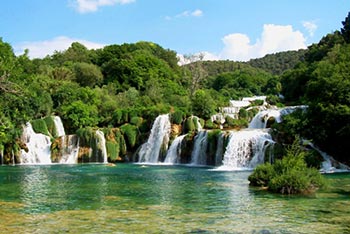 National Park Krka (since January 24, 1985) - The empire of Krka River, the magnificent karstic beauty traveling two thirds of its way to the sea through canyons, is a complete opposite of Kornati. On its green path, it has seven falls, the last one being Skradinski buk with an average flow of 55 cubic meters of water per second. National Park Krka is rich in flora and fauna. 222 bird species live there, making it one of the most valuable ornithological areas in Europe. You can visit it by boat, car or on foot. Make sure you visit the ethno museum on one of the old mills. National Park Krka also has the only hawk training center in Croatia where you can se presentations of hunting with hawks and hawk trainers’ skills. Each of the islands within the Šibenik archipelago, arranged across the vast area of the open sea, hides an interesting feature. Zlarin has the most famous coral divers, while Krapanja, a small town on the smallest island in the region of the same name,
is known for its sea sponge divers. The Sibenik region is one of the Mediterranean’s quieter corners where there is still the space and time to make discoveries in a fascinating and varied landscape. The Krka National Park and the town of Sibenik are symbolic of the contrasts that are found in central Dalmatia. There are the rugged limestone mountains of the mainland set against the intricate archipelagos of the Adriatic Sea. And there is the diversity and natural beauty of the various parks and reserves in combination with the rich and well-preserved cultural heritage of the ancient coastal settlements. It is a landscape that offers much to the interested visitor and which, thankfully, remains free from the concrete development of resorts. Mediterranean summers: Sibenik and the central Dalmatian coast enjoy a pleasant Mediterranean climate with warm, dry summers coupled with cooling sea breezes and the temptations of the Adriatic. Inland, in the national park, the river and the
waterfalls counteract the heat. In winter it is mild and wet, but note that much is likely to be closed… (9ANP-003, 9AFF-003)
National Park Krka (since January 24, 1985) - The empire of Krka River, the magnificent karstic beauty traveling two thirds of its way to the sea through canyons, is a complete opposite of Kornati. On its green path, it has seven falls, the last one being Skradinski buk with an average flow of 55 cubic meters of water per second. National Park Krka is rich in flora and fauna. 222 bird species live there, making it one of the most valuable ornithological areas in Europe. You can visit it by boat, car or on foot. Make sure you visit the ethno museum on one of the old mills. National Park Krka also has the only hawk training center in Croatia where you can se presentations of hunting with hawks and hawk trainers’ skills. Each of the islands within the Šibenik archipelago, arranged across the vast area of the open sea, hides an interesting feature. Zlarin has the most famous coral divers, while Krapanja, a small town on the smallest island in the region of the same name,
is known for its sea sponge divers. The Sibenik region is one of the Mediterranean’s quieter corners where there is still the space and time to make discoveries in a fascinating and varied landscape. The Krka National Park and the town of Sibenik are symbolic of the contrasts that are found in central Dalmatia. There are the rugged limestone mountains of the mainland set against the intricate archipelagos of the Adriatic Sea. And there is the diversity and natural beauty of the various parks and reserves in combination with the rich and well-preserved cultural heritage of the ancient coastal settlements. It is a landscape that offers much to the interested visitor and which, thankfully, remains free from the concrete development of resorts. Mediterranean summers: Sibenik and the central Dalmatian coast enjoy a pleasant Mediterranean climate with warm, dry summers coupled with cooling sea breezes and the temptations of the Adriatic. Inland, in the national park, the river and the
waterfalls counteract the heat. In winter it is mild and wet, but note that much is likely to be closed… (9ANP-003, 9AFF-003)
|
 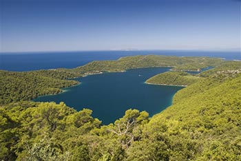 National Park Mljet (since November 12, 1960) - was established in early sixties of last century. It covers about 30 square kilometers of area on the western bit of Island MLJET, which is about 1/3 of the Island. It consist of two natural salt lakes (Veliko and Malo jezero) that are interconnected by a narrow channel. Veliko jezero (Large Lake) covers the area of 1,5 square kilometers. Malo Jezero (Small Lake) is about 1/4 of square kilometers. The salinity of the water in the lakes is bit lower than in the sea, due to intake of fresh waters. The temperature of the Lakes is usually higher then open sea temperatures for about 4 degrees centigrade. Due to these details, Veliko and Malo Jezero are popular places for visitors to swim in. Both lakes are surrounded with dense old pine forest. In the middle of Veliko Jezero there is a little island called Melita where Benedictine monastery is located. National Park Mljet is often referred to as the most beautiful Adriatic
island because it has some truly rare sites – a lake in the middle of the island and an island in the lake with a castle on the island, a Benedictine monastery from the 12th century. This almost surreal image seems to have been extracted from the most beautiful stories. According to one of them, Mljet was part of Odysseus’ route and nymph Calypso kept him in captivity there… (9ANP-004, 9AFF-004)
National Park Mljet (since November 12, 1960) - was established in early sixties of last century. It covers about 30 square kilometers of area on the western bit of Island MLJET, which is about 1/3 of the Island. It consist of two natural salt lakes (Veliko and Malo jezero) that are interconnected by a narrow channel. Veliko jezero (Large Lake) covers the area of 1,5 square kilometers. Malo Jezero (Small Lake) is about 1/4 of square kilometers. The salinity of the water in the lakes is bit lower than in the sea, due to intake of fresh waters. The temperature of the Lakes is usually higher then open sea temperatures for about 4 degrees centigrade. Due to these details, Veliko and Malo Jezero are popular places for visitors to swim in. Both lakes are surrounded with dense old pine forest. In the middle of Veliko Jezero there is a little island called Melita where Benedictine monastery is located. National Park Mljet is often referred to as the most beautiful Adriatic
island because it has some truly rare sites – a lake in the middle of the island and an island in the lake with a castle on the island, a Benedictine monastery from the 12th century. This almost surreal image seems to have been extracted from the most beautiful stories. According to one of them, Mljet was part of Odysseus’ route and nymph Calypso kept him in captivity there… (9ANP-004, 9AFF-004)
|
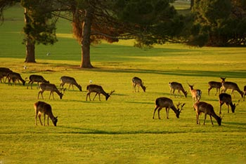
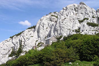
 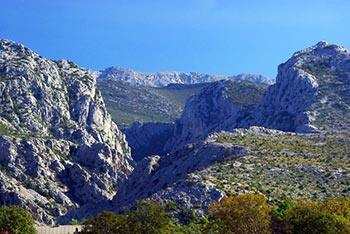 National Park Paklenica (since October 19, 1949) - Paklenica is an area of unusual contact between the sea and the mountain, rich in natural forests of beech, black pine and mountain pine... Paklenica is Croatian National park that cover the most attractive parts of southern Velebit, as well as its highest peaks, all located in Lika region. Paklenica is an area of unusual contact between the sea and the mountain, rich in natural forests of beech, black pine and mountain pine. This is a habitat for the endemic plant called pljeskarica in Croatian (Arenaria orbicularis) and other plant and animal rarities, filled with karstic forms. It is famous for some parts of Mala Paklenica and Velika Paklenica. National Park Paklenica covers an area of 96 km2. The highest peaks is Sveto brdo (1753 m). The main attraction of the Paklenica Park are two impressive canyons of Velika and Mala Paklenica, vertically cut into the mountain from the sea to the Velebit's highest peaks. In
this small area of the national park, there are several unusual carst forms, caves, and varied flora and fauna. There are various species of large mammals in the park. too. Throughout the park, one can see game species such as roe deer , red deer , chamois and wild boar. Large predator species include the brown bear, the wolf and the lynx - though there are not a lot of visitors who can claim seeing them... (9ANP-005, 9AFF-005)
National Park Paklenica (since October 19, 1949) - Paklenica is an area of unusual contact between the sea and the mountain, rich in natural forests of beech, black pine and mountain pine... Paklenica is Croatian National park that cover the most attractive parts of southern Velebit, as well as its highest peaks, all located in Lika region. Paklenica is an area of unusual contact between the sea and the mountain, rich in natural forests of beech, black pine and mountain pine. This is a habitat for the endemic plant called pljeskarica in Croatian (Arenaria orbicularis) and other plant and animal rarities, filled with karstic forms. It is famous for some parts of Mala Paklenica and Velika Paklenica. National Park Paklenica covers an area of 96 km2. The highest peaks is Sveto brdo (1753 m). The main attraction of the Paklenica Park are two impressive canyons of Velika and Mala Paklenica, vertically cut into the mountain from the sea to the Velebit's highest peaks. In
this small area of the national park, there are several unusual carst forms, caves, and varied flora and fauna. There are various species of large mammals in the park. too. Throughout the park, one can see game species such as roe deer , red deer , chamois and wild boar. Large predator species include the brown bear, the wolf and the lynx - though there are not a lot of visitors who can claim seeing them... (9ANP-005, 9AFF-005)
|
 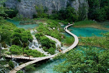 National Park Plitvice Lakes (since April 8, 1949) - is Croatia's well known national park. Plitvice Lakes are also listed in UNESCO's Register of World Natural Heritage. Plitvice Lakes is a group of sixteen small lakes - Proscansko Jezero, Labudanovac Lake, Ciganovac Lake, Galovac Lake, Kozjak Lake... - mutually connected with numerous large and smaller waterfalls. Plitvice waterfalls are created by deposition of travertine -a kind of limestone that created this unique and attractive wonder of nature. Plitvice National Park is the area surrounded by dense forests of beech, fir and spruce, watered by various springs of the Korana River. Plitvice National Park is decorated with several caves and flower meadows too. Brown bear found , among other animal species, their home in Plitvice Lakes too. Area of Plitvice Lakes is paradise for walkers and hikers as well as nature lovers. Lakes are lovely and cool in summer, icy and calm in winter, yellow and ochre in autumn,
green and fresh in spring - any time of the year it is a privilege to be around those lakes! Plitvice Park is conveniently located near the main road that connects Zagreb and Croatia Adriatic Coast. It is easily accessible by public transport as well as by bicycle, from Karlovac, Zagreb or Split. Due to it's popularity among Croatian as well as other visitors, there are various accommodations available in and around Plitvice Lakes including several nearby campsites... (9ANP-006, 9AFF-006)
National Park Plitvice Lakes (since April 8, 1949) - is Croatia's well known national park. Plitvice Lakes are also listed in UNESCO's Register of World Natural Heritage. Plitvice Lakes is a group of sixteen small lakes - Proscansko Jezero, Labudanovac Lake, Ciganovac Lake, Galovac Lake, Kozjak Lake... - mutually connected with numerous large and smaller waterfalls. Plitvice waterfalls are created by deposition of travertine -a kind of limestone that created this unique and attractive wonder of nature. Plitvice National Park is the area surrounded by dense forests of beech, fir and spruce, watered by various springs of the Korana River. Plitvice National Park is decorated with several caves and flower meadows too. Brown bear found , among other animal species, their home in Plitvice Lakes too. Area of Plitvice Lakes is paradise for walkers and hikers as well as nature lovers. Lakes are lovely and cool in summer, icy and calm in winter, yellow and ochre in autumn,
green and fresh in spring - any time of the year it is a privilege to be around those lakes! Plitvice Park is conveniently located near the main road that connects Zagreb and Croatia Adriatic Coast. It is easily accessible by public transport as well as by bicycle, from Karlovac, Zagreb or Split. Due to it's popularity among Croatian as well as other visitors, there are various accommodations available in and around Plitvice Lakes including several nearby campsites... (9ANP-006, 9AFF-006)
|
 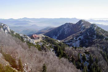 National Park Risnjak (since September 15, 1953) - Risnjak (1528 m) is the second highest mountain in Gorski kotar. In 1953, it became the national park of the Republic of Croatia. Reasons for that are different, but can be summed up to the following: On the relatively small area, there is a great variety of the first class geographical, geological, and other natural phenomena, easily accessible for visitors. The natural beauties are almost untouched by man. National Park Risnjak is situated in the Mount Risnjak massif and its 1528 meter peak being the basis of the park. To enjoy the beauties of Risnjak, you need to have a special sense for the thrills of natural phenomena. National Park Risnjak is based in Crni Lug near Delnice has 6,400 hectares of forest areas. With over thirty specific plant communities, a 4.2-kilometers long trail, a mountain lodge, a restaurant and accommodation capacities, it represents a special attraction and value of Kvarner and Gorski Kotar
- a wide, heavily forested, karst plateau rising to jagged peaks. Easily accessible, owing to the proximity of the main Zagreb–Rijeka road, the area is a popular destination with Croats for walking, climbing and mountaineering. Risnjak National Park is at the northern end of the plateau and covers over 30 sq km rising from the tableland at 620m to the main peak, Risnjak, at 1,528m. The park’s varied climatic influences – the sea from the south-west, the Dinaric mountains from the south-east, the continent from the north-east and the Alps from the north-west – have enabled over 4,000 plant species to prosper. Accompanying these are over a hundred brown bears, lynx (ris in Croatian and after which the park is named), wolves, wild cats, wild boar, deer and chamois, as well as 500 species of butterfly. (9ANP-007, 9AFF-007)
National Park Risnjak (since September 15, 1953) - Risnjak (1528 m) is the second highest mountain in Gorski kotar. In 1953, it became the national park of the Republic of Croatia. Reasons for that are different, but can be summed up to the following: On the relatively small area, there is a great variety of the first class geographical, geological, and other natural phenomena, easily accessible for visitors. The natural beauties are almost untouched by man. National Park Risnjak is situated in the Mount Risnjak massif and its 1528 meter peak being the basis of the park. To enjoy the beauties of Risnjak, you need to have a special sense for the thrills of natural phenomena. National Park Risnjak is based in Crni Lug near Delnice has 6,400 hectares of forest areas. With over thirty specific plant communities, a 4.2-kilometers long trail, a mountain lodge, a restaurant and accommodation capacities, it represents a special attraction and value of Kvarner and Gorski Kotar
- a wide, heavily forested, karst plateau rising to jagged peaks. Easily accessible, owing to the proximity of the main Zagreb–Rijeka road, the area is a popular destination with Croats for walking, climbing and mountaineering. Risnjak National Park is at the northern end of the plateau and covers over 30 sq km rising from the tableland at 620m to the main peak, Risnjak, at 1,528m. The park’s varied climatic influences – the sea from the south-west, the Dinaric mountains from the south-east, the continent from the north-east and the Alps from the north-west – have enabled over 4,000 plant species to prosper. Accompanying these are over a hundred brown bears, lynx (ris in Croatian and after which the park is named), wolves, wild cats, wild boar, deer and chamois, as well as 500 species of butterfly. (9ANP-007, 9AFF-007)
|
  National Park North Velebit (since June 2, 1999) - includes a diversity of karstic phenomena, flora and fauna, which is just a part of this natural world. The Park covers the surface of 109 km2, and inside there is the Hajdučki & Rožanski Ledges Strict Reserve, known for its geomorphological phenomena - the pits. There are more than 150 pits discovered, out of which the most famous is Luke's pit, discovered in 1992. Velebit is an untamed mountainous ridge which looms as large in the Croatian mentality as it does on the ground. Lying adjacent to the Adriatic and occupying over 2,000 sq km in a belt 145km long and up to 30km wide, this limestone mass is a designated UNESCO biosphere reserve. Velebit is perfect for those wanting to explore a fascinating area in solitude. It is possible to hike the whole length of the ridge, following Premuzic’s path and staying in mountain huts, whilst the more compact Paklenica National Park also offers excellent walking opportunities.
Despite its proximity to the coast and the pleasant climate of nearby island archipelagos, Velebit’s size ensures that only on the coastal slopes is it typically Mediterranean. On the top of the ridge the climate is consistently continental, with intense summers exacerbated by the scarcity of surface water and then followed by cold, harsh winters. The peaks of Velebit endure temperatures below 0°C on 160 days in a year. July to September are thus the best months to visit… (9ANP-008, 9AFF-008)
National Park North Velebit (since June 2, 1999) - includes a diversity of karstic phenomena, flora and fauna, which is just a part of this natural world. The Park covers the surface of 109 km2, and inside there is the Hajdučki & Rožanski Ledges Strict Reserve, known for its geomorphological phenomena - the pits. There are more than 150 pits discovered, out of which the most famous is Luke's pit, discovered in 1992. Velebit is an untamed mountainous ridge which looms as large in the Croatian mentality as it does on the ground. Lying adjacent to the Adriatic and occupying over 2,000 sq km in a belt 145km long and up to 30km wide, this limestone mass is a designated UNESCO biosphere reserve. Velebit is perfect for those wanting to explore a fascinating area in solitude. It is possible to hike the whole length of the ridge, following Premuzic’s path and staying in mountain huts, whilst the more compact Paklenica National Park also offers excellent walking opportunities.
Despite its proximity to the coast and the pleasant climate of nearby island archipelagos, Velebit’s size ensures that only on the coastal slopes is it typically Mediterranean. On the top of the ridge the climate is consistently continental, with intense summers exacerbated by the scarcity of surface water and then followed by cold, harsh winters. The peaks of Velebit endure temperatures below 0°C on 160 days in a year. July to September are thus the best months to visit… (9ANP-008, 9AFF-008)
|